Highland Hills to Boardwalk Loop
START / FINISH: Highland Hills Mall, Kitchener
It is suggested you use the parking lot near the Highland Hills Beer Store at about 43.430845, -80.526831.
Description of this 7.5 km Loop Hike (counter clockwise)
NOTE: A print friendly PDF file of the list below is available for download here.
1. From the Highland Hills parking lot walk past the
Beer Store to the traffic light at Highland Rd and
Fischer-Hallman Rd and cross twice to the sidewalk in
front of the Husky Gas Station.
2.
Proceed along the Fischer-Hallman Rd sidewalk in front
of the Husky Gas Station a short distance (~ 60m) to
Sandrock Creek.
3. At Sandrock Creek turn right
(north east) along the trail with the creek on your left
for about 520 m.
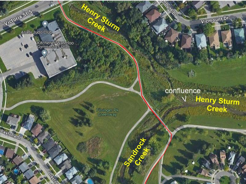
4. As you read Step 4, also examine
the first map image below. Take the trail left (north)
across Sandrock Creek on a steel bridge for about 70 m &
veer right for ~ 180 m to Victoria Street South [Shortly
after crossing the bridge, veering right look for the
confluence of Sandrock Creek with Henry Sturm Creek. Henry Sturm Creek
will be on the right (east). The two creeks form a
confluence. As you proceed to Victoria Street South the
creek on the right is now called Henry Sturm Creek. The
two creeks merge at about
43.436860, -80.522509.]
5. Upon arriving at
Victoria Street South the trail to follow is straight
ahead across the street. CAUTION: Due to heavy
traffic, it is suggested you use the traffc lights
nearby to cross Victoria Street South and then return to
the trail on the north side of Victoria Street.
6.
From Victoria Street follow the trail for about
0.5 km with Henry Sturm
Creek on your left to and under Fischer-Hallman Road.
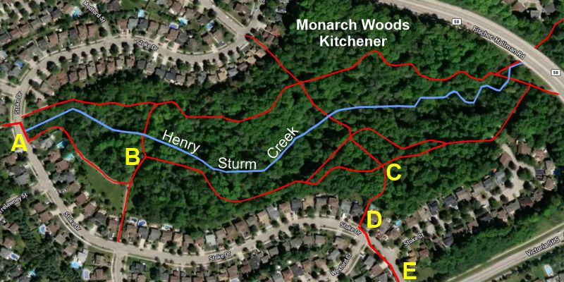
You have entered a section called Monarch Woods. Monarch
Woods has two routes passing from east to west. One
route is north of Henry Sturm Creek and the other one is
south of it. For this walk I suggest taking the north
route through Monarch Woods(creek on your left) that is
approximately 0.8 m long. You exit Monarch Woods at
43.437451, -80.539617 on a cirve of Stoke Drive.
7. Cross Stoke Drive and follow the trail about 0.2 km
to a large open field (43.438138,
-80.542712). Leaving the groomed trail, cross the
open field in a north-west direction until you arrive at
a stone dust trail and veer left (west) and parallel to
the rain tracks on your right. [Note that off to your
right, over the train tracks, but not visible, is
Ressurection Catholic Secondary School.].
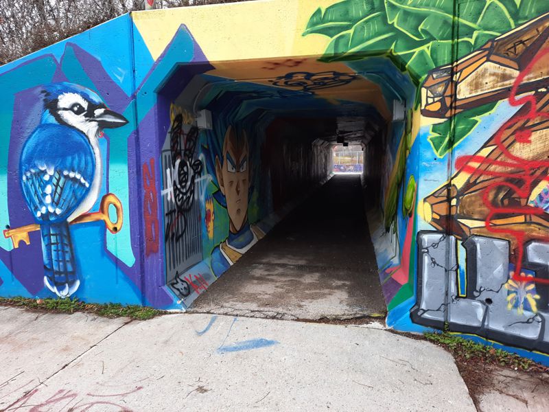
8. Continue
a short distance until you arrive at an obvious tunnel
[see image below.] and pass through the tunnel to the north side of the
train tracks.
9.
After passing through the tunnel veer right then left
and upward for about 0.1 km on a concrete path. Near the
top keep left (west) on the trail behind housing. [Do
not go out to Resurrection Drive.] Follow this trail
south-west for about 0.4 km to a Stormwater Pond. As you
walk this segment the train tracks and Henry Sturm Creek
will be on the left (housing on the right).
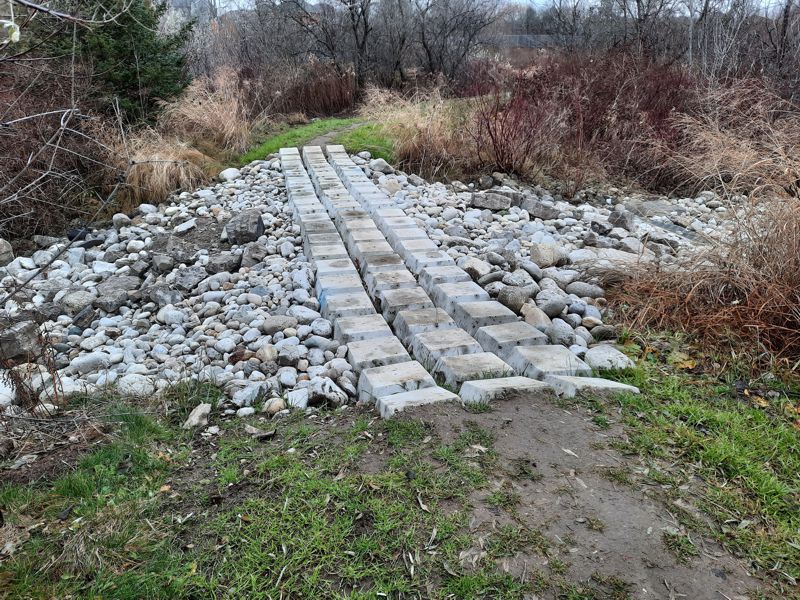
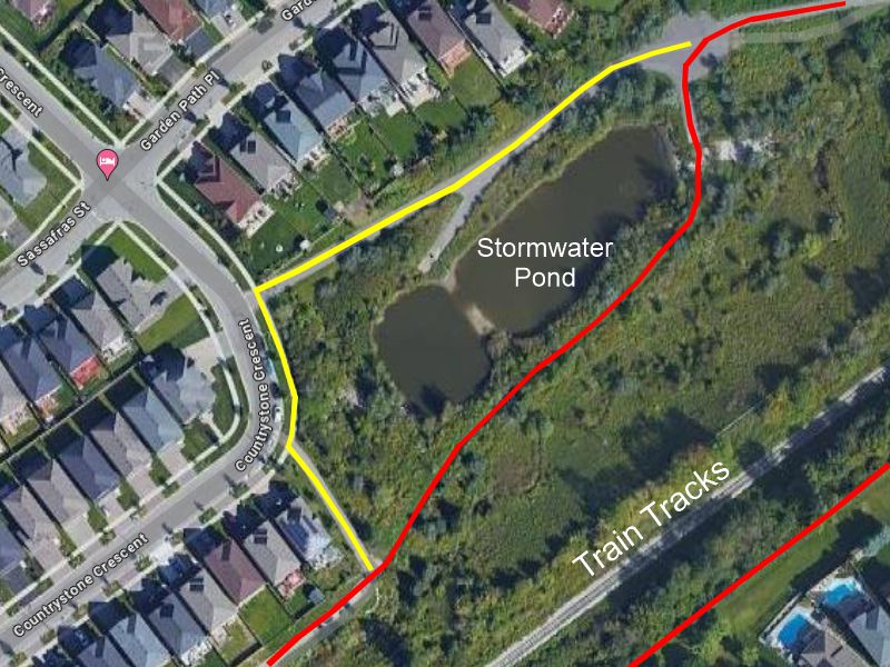
10. As
you arrive at the Stormwater Pond the trail becomes a
large pad. Veer left to the south side of
the Stormwater Pond to a "bridge" (refer to the map and
photograph below) and a footpath. Follow the footpath
for about 170 m where it rejoins a paved trail behind
houses.
11. Continue westward for about 0.2 km until
you are at an embankment that leads upward to the Ira
Needles Blvd. Go up to the sidewalk and turn left
(south) if you are not going to the Boardwalk.
12.
Once you are at about
43.432184, -80.555110, turn left and down the
embankment to the south side of the train tracks and
entering a green space called Huck Park Greenway.
13.
Proceed eastward on the grass through Huck Park Greenway
staying close to the the train tracks (on your left).
After about 0.16 km you will proceed eastward on a stone
dust trail with houses on the right and the train tracks
on the left.
14. At about
43.435124, -80.550055 veer right and out to
Westforest Trail (street) and follow the sidewalk
eastward for about 0.3 km.
15. Veer left and off the
sidewalk onto the trail that takes you to the train
tunnel. Veer right (not passing through the tunnel) and
follow the same route back out to Stove Drive.
16.
Cross Stoke Drive and go right about 30 m and enter
Monrach Woods at about
43.437151, -80.539476. Proceed through Monarch Woods
on the south side of Henry Sturm Creek to an exit at
C>D>E depicted on the image below.
17. Cross Victoria
Street at the designated crosswalk (43.434978,
-80.533212) and follow the sidewalk about 0.4 km
down Oprington Drive, left on Bankside sidewalk for
about 0.3 km. Just after passing Chartwell Bankside
Retirement Residence turn right on a path out to
Highland Road and the traffic light. Cross over and head
to your car(s).
Confluence of Sandrock & Henry Sturm Creeks
43.436858, -80.522505
Tunnel Under Train Tracks
43.436950, -80.547420
Bridging at Stormwater Pond
43.435234, -80.552319
Alternate Route in Yellow
Return Through Monarch Woods
A>B>C>D>E
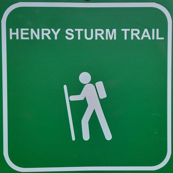
Typical signage near Ira Needles Blvd
Various pathways to Ira
Needles from
Highland Hills Mall and Back
GPS Tracks for Download
HELP: If clicking on the links does not provide a download option, try RIGHT clicking the link (especially the .gpx file) and then choose "Save Links As" (or equivalent) from the drop-down menu. Pick a download location (e.g. desktop) for the file.
HighlandHillsToBoardwalkLoop.gpx
OR HighlandHillsToBoardwalkLoop.kml