Walker Woods Trail
... a Wilmot Township TrailPage Index
Two Hike Suggestions | Introduction/History | Award of Excellence to Roy Walker Roth | Volunteers Build Trail in Walker Woods
| Rules & Keep Track | Enter at Your Own Risk | In an Emergency | Entrances to Trail | Parking | Map |
Other Links
| Map 8 km | Map 3 km |
Free GPS Tracks for Download
Two Hike Suggestions
Option One > Park in the business area of New
Hamburg. Walk out to and through Walker Woods and then
back to New Hamburg for a total of about 8 km.
Option
Two > Walk through Walker Woods only for a total of
about 3 km.
Introduction / History
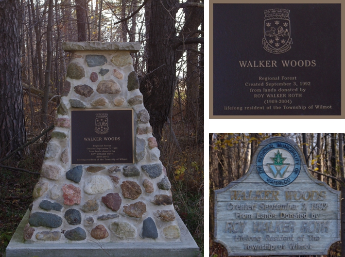
In the Fall of 2012 Avon Trail volunteers assisted Wilmot Township volunteers in the development of a trail in Walker Woods near New Hamburg. This trail is open for hiking and snowshoeing. The three pictures immediately below were taken at the Walker Road entrance >> Google Maps approximate location of the Walker Woods Trail entrance on Walker Road (43.360912,-80.707337) | Google Street View of entrance.
Award of Excellence to Roy Walker Roth
In 1992 the Waterloo Regional Heritage Foundation named Roy as a recipient of its "Awards of Excellence". The Awards of Excellence, inaugurated in 1983, are intended to recognize outstanding contributions by individuals, institutions and organizations to heritage preservation in Waterloo Region, in such areas as archaeology, archives, culture, education, genealogy, history, literature, media, natural history and others.
Volunteers Build Trail in Walker Woods
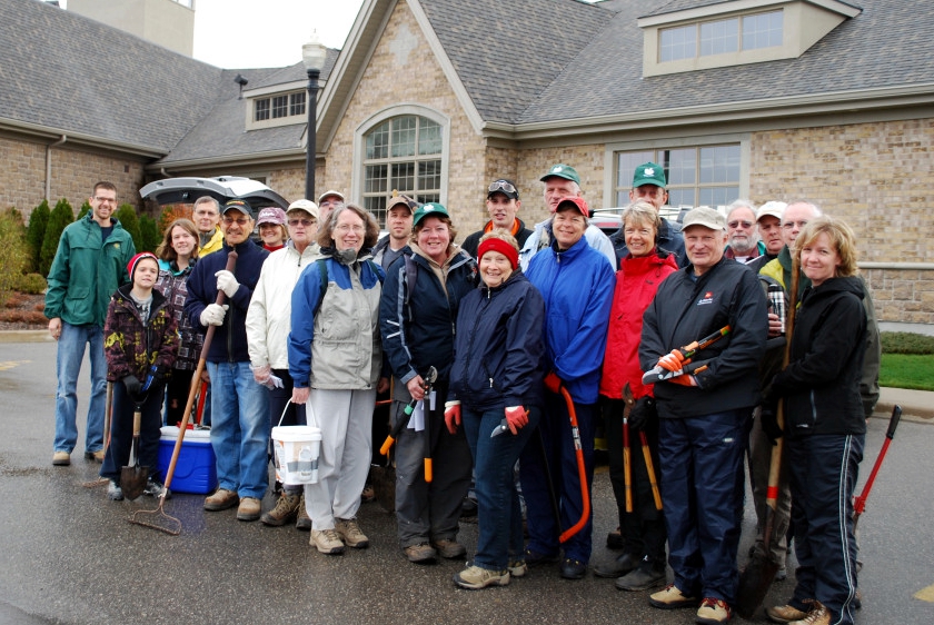
Shown above are 8 Avon Trail maintenance crew and about 14 Wilmot Township volunteers from two different days. After a workshop in the Stonecroft Recreation Centre (building behind group) on how to build and maintain trails, the crews headed out to build the trail. Far left in the green jacket is Andrew Martin, Planner, Wilmot Township, the initiator of the project. [Picture credit: Bernard]
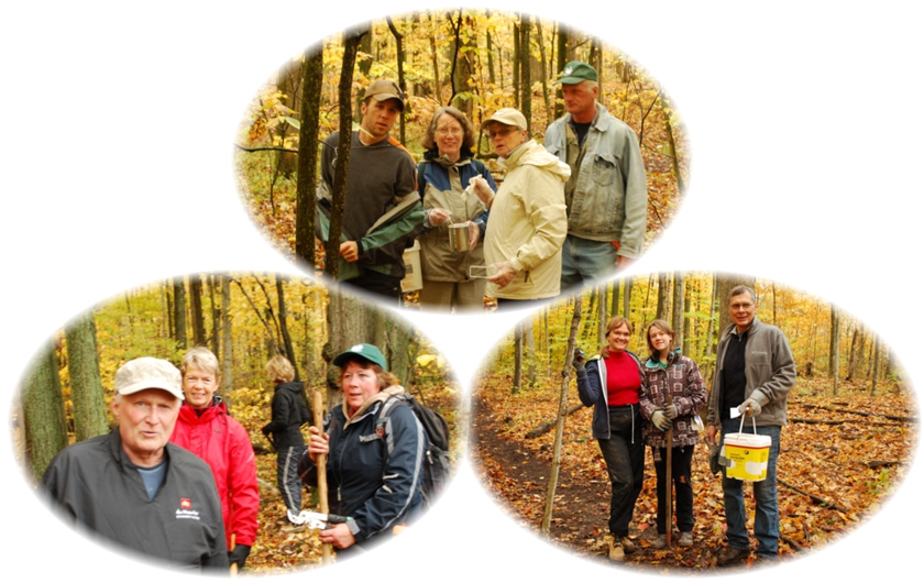
There were 4 or 5 crews each consisting of a couple of Avon Trail maintenance crew and 3 or 4 Wilmot Township volunteers. They learned about trail clearing and blazing. The young lady (centre in the bottom right picture) is a high school student earning credit towards her volunteer hours requirement for graduation. There were about 30 Wilmot volunteers over two days. [Pictures credit: Bernard]
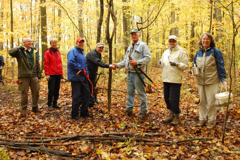
Different teams worked at different points on the trail. Wilmot Township volunteer (left) shakes hands with Luke deBrabandere, Avon Trail (right). The handshake represents the two perimeter groups meeting, thus completing the 3.5 km perimeter trail being cleared and blazed. [Picture credit: Bernard]
WALKER WOODS RULES
- 1. Open only during daylight hours
- 2. No ATV’s, Dirt Bikes, Snowmobiles or other Motorized vehicles
- 3. No Hunting or Target Shooting
- 4. No Fires
- 5. Stay on marked trails
- 6. Dogs must be on leash & please stoop, scoop & carry out the poop
KEEP ON TRACK
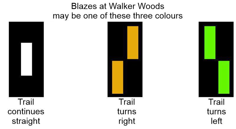
The Walker Woods Trail is marked by blazes (see image above). The blazes are painted indicators, 5 cm x 15 cm rectangles. You will find the markings on trees and other noticeable features trail-side. Typically the blazes are on the right side as you travel along the path. A single blaze indicates the trail continues straight ahead, more or less. Double blazes indicate a directional change of the trail. On double blazes it is the upper marker that indicates the direction to follow.
ENTER AT YOUR OWN RISK
Trail use is a potentially dangerous activity carrying a significant risk which could result in injury, including severe or catastrophic injury or death, or property damage and should only be undertaken by an individual with the full understanding of all inherent risks. When entering the property of the Regional Municipality of Waterloo or the Corporation of the Township of Wilmot and using any of the Regional Municipality of Waterloo’s or the Corporation of the Township of Wilmot’s lands, including the designated trails, for any purpose whatsoever, you assume the full and complete risk of any injury, including catastrophic or fatal injury, and/or damage to personal property which you may suffer or incur.
IN AN EMERGENCY

In an EMERGENCY situation whenever police, fire, or ambulance assistance is required immediately, telephone 911. If you are unsure, call 911 and the communicator will help make a determination. When calling 911, report your location by stating the Municipal Address Number identified at the two entrance locations as well as on the trail map.
ENTRANCES TO TRAIL
Stonecroft Entrance/Parking Lot:
89 Bonaventure Drive (43.365407,-80.699775)
at the "roundabout" where Bonaventure Drive and Stonecroft Way meet.
Walker Road Entrance: 2107 Walker Road (43.360908,-80.70734) > Google Maps Street View showing monument).
PARKING
Google Maps of Walker Woods Trail Entrance Points created by Wilmot Township - see margin at left of Google Maps web page.
If you park at the Walker Road entrance (not recommended) be sure to have the vehicle(s) well off the road and not blocking the entrance. The entrance may be required for emergency vehicles.
Parking at municipal address
89 Bonaventure Drive
(43.365387, -80.699667) is best for the short 3 km walk) - see map below
Further Information
Check this Wilmot Township web page for more information. In addition this is a link to the Wilmot Township PDF map of the Walker Woods Trail that sows the colur coded blazing.
Other Links
Wilmot Township Website > Walker Woods web page
Official Township PDF Map of Trail posted by Wilmot Township
GPS Track - 8 km Walk (starting in New Hamburg)
GPS Track - 3 km Walk (starting at Stonecroft)
GPS Tracks for Download
HELP: If clicking on the links does not provide a download option, try RIGHT clicking the link (especially the .gpx file) and then choose "Save Links As" (or equivalent) from the drop-down menu. Pick a download location (e.g. desktop) for the file.
WalkerWoodsOnly.gpx
OR WalkerWoodsOnly.kml - 3 km
WalkerWoodsFromNewHamburg.gpx
OR WalkerWoodsFromNewHamburg.kml - 8 km